|
SPRR Yuma District - The East Line SEGMENT 5: Introduction
The Yuma Territorial Prison was built here
in 1876 adjacent to The weather is pleasant in the winter and
furnace-like during summer; long ago the heat was a bit more bearable
but the intense agriculture along the river has forced up the humidity
and so made the heat more sweltering.
As along most of the rest of the railroad,
the Espee shares their right-of-way with oil and gas pipelines and telecommunications
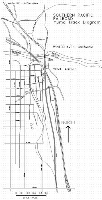
companies. 732.5 West End YUMA Yard Limits End Single Track
Centralized Traffic Control (CTC) Begin Double Track
Automatic Block Signal (ABS) Spring Switch EB/WB Absolute
Signals Signpost WB "END
OF DOUBLE TRACK" Signpost WB "BEGIN
CTC" Signpost EB "END
CTC" Enter Speed Limit: EB
25 MPH; WB 25 MPH To the east the railroad runs under double-track
ABS (Automatic Block Signal) control all the way to MP737.4 at the east
end of East Yard. Westbound
the railroad maintains single-track CTC (Centralized Traffic Control)
jurisdiction for just 0.4 miles to MP732.1, where two-main-track CTC
begins and continues west. The following five miles of double track
are run with respect to the current of traffic: the #1 (north) track
provides westbound service while the #2 (south) track sees eastbound
traffic. All of the signals controlling this double
track are set up for operation in those directions. For instance, any time a westbound train
is run on the south track, it is said to be running against the current
of traffic (ACOT), and so is controlled by certain rules governing that
service. The turnout that joins the #1 and #2 tracks
immediately east of the On the low hill immediately along the side
of the tracks rests the old Yuma Territorial Prison, built in 1876 by
its own inmates. It is now
the Besides all the historical information
and artifacts concerning life in general in the surrounding country,
the museum also displays a few drawings and photos of the river crossing:
before the railroad; after arrival of the railroad in 1877; and lastly,
a particularly nice photo (hidden, of course, in a back office) taken
of the old highway bridge during its construction, before the current
railroad bridge was built. Of
course, that old highway bridge ( Also note the "No Trespassing - SPT
Co." sign at the east portal of the 732.6 West End Interstate 8 Overpass SP Maintenance
of Way Facility The west-facing switch off the #2 track
just north of the Interstate 8 overpass is the Yuma Yard lead; this
drill track parallels the double-track main all the way to the end of
the East Yard at MP737.7. The east-facing switch on the yard lead
under the overpass is the junction point with the Yuma Valley Railroad. The YVRR is an Espee branchline that extends
about six miles downriver to a water desalinization plant. At one time the branch continued all the
way down the The Espee MofW facility is south of the
Interstate overpass; the access road to this yard leads in from the
intersection of St. Thomas Road and First Street, back at the stop sign
at the foot of the old highway bridge. 732.7 SP Section House Crew Change Facility Amtrak Depot SP Police Station End Begin Gila Line
( This station was built in the mid-Twenties
to service the new mainline when the current The original station building is now home
to the There are two train platforms; the one
between the tracks is accessible via a passenger subway that lies just
south of the The present SP building is the two-story
structure just south of the passenger walkway; the SP Police hang out
on the first floor, and their vehicles are the white trucks parked out
front. The second floor houses the crew change
quarters, the Amtrak ticket office, and probably the local Yuma Line
Desk operator (that's the Yardmaster, more or less: Rule 7(a) specifies
that "Trains must not enter or depart yard unless authorized by
trainmaster"). On the east side of the tracks, across
from the station, are the footings of a long-gone water tank. This is technically the end of the Los
Angeles Division and the beginning of the Tucson Division; however,
Rule N in the Espee Rulebook specifies that the first five miles of
the Gila Line (to the east) is under the jurisdiction of the Los Angeles
Division. 732.8 Access to Railroad from A dirt incline leads up from The tracks cross Giss on a 50'-steel through-plate
girder bridge; the bridge is wide enough to also provide room for the
westside access road. 733.0 145' AMSL; +0.2% EB Speed Limit: EB
50 MPH (#2 Track); EB 25 MPH (#1 Track) 733.1 Block Signals: WB 7331/7333 According to the timetable, Rule 301 specifies
that the "Signal 7333 governs westward movement through crossover
to main track only and will remain dark until crossover switch is open". 733.5 Abandoned Alignment approaches from
West The original route through 734.3 SUBWAY Station Block Signals:
EB 7340 - WB 7341 Subway Crossover East End 155' AMSL; +0.6%
EB The crossover allows westbound traffic
on the #2 (south) track to move onto the #1 track. The switch on the #2 track, just east of
the crossover, provides access to the east end of the Yuma Yard lead. Often, if a westbound train will be laying
over at On the west side of Interstate 8 at the
734.4 Block Signals: WB 7341/7343 Grain Loader on
East-facing 0130 Spur off Drill Track Rule 241: "Train or engine must be
authorized to move against current of traffic before passing signal
7343". An obscure road
leads down from Access along the tracks to the east is
available from the dirt parking lot west of the McDonalds; a fine path
passes around the west side of the "YUMA" water tank, then
drops down to parallel the tracks at about MP734.6. 734.5 Speed Limit: EB 50 MPH; WB 25 MPH The mainline begins to curve to the east. 734.8 West Switch The wye is south of the mainline and is
switched off the drill track that parallels the main. 734.9 The Diesel Facility performs minor service
on locomotives, mainly just enough to keep them running to either The plant is on the south side of the right-of-way,
sitting in the middle of the triangle formed by the wye trackage. The wye tail track juts out to the west
about two-tenths of a mile. Speed
limit on Diesel Facility trackage is 5 MPH. The access path along the north side of
the tracks continues both east and west; the soil is a little silty
but passable. To the west the road eventually gets to A dirt road leads in from 735.0 185' AMSL; +0.6% EB 735.1 Dragging Equipment DETECTOR (#1
Track) 735.2 Speed Limit: WB 40 MPH East Switch The 0314 switch connects the east leg of
the wye to the drill track that parallels the mainline to the south. 735.3 East-facing Spur 0353 (#1 Track) Spur 0353 joins the north main; the spur
leads west and downhill to serve a couple of industries that front on
The north trackside access path continues
east all the way to the Pacific Avenue Overpass at MP735.6. 735.4 East-facing Spur 0401 on South Drill
Track West-facing Spur
0405 on South Drill Track Both of these industry spurs connect to
the drill track that parallels the double track mainline along its south
side. The northside access path passes under
the overpass bridge and continues both east and west. A rough trail from the southwest corner
of 735.6 West East Yard Crossover A signal bridge lies east of the Pacific
Avenue Overpass; on it are two signals controlling eastward progress
on the #1 (north) track through the crossover to the west end of the
East Yard ladder track. 735.9 Block Signal: WB
7359 East Yard stretches east for the next two
miles; it is often used to hold trains for extended periods, and it
is also where outgoing produce trains are assembled. The single signal controls westward movement
on the #1 track. The dirt path along the north side of the
tracks continues west under the 736.0 220' AMSL; +0.1% EB 736.6 Avenue 3E Overpass Avenue 3E is an offramp from both directions
of Interstate 8, about 0.5 miles north of the railroad. 736.8 Military Base Spur Track An east-facing spur separates from the
south side of East Yard and parallels Avenue 3E south, throwing off
a further few east-facing spurs on its way to the Marine Corps airfield
that doubles as 737.0 225' AMSL; +0.0% EB There is limited access along the north
side of the tracks from the Avenue 3E bridge to about MP737.2. Of course, with a proper four-wheel drive
vehicle, the sky's the limit (but you weren't interested in the sky,
it was the tracks you were after). For everyone else, most all trails lead
to 737.2 Signpost WB 40 MPH 737.5 End End Two Main Track
Absolute Block Signal (ABS) Begin Single Track
Centralized Traffic Control (CTC) Absolute EB Signals East-facing Spring
Switch West-facing Industry
Spur (#1 Track) Signpost EB "Begin
CTC" Signpost WB "End
CTC" This marks the end of the Yuma Yard limits,
which start back at MP732.5. Here
at the east end of East Yard, the ladder track joins with the drill
track that has paralleled the main line since MP732.6. A east-facing spring switch, just like
the one back at MP732.5, controls the junction, allowing eastward traffic
on the drill lead to get onto the #2 track without requiring the switch
points to be controlled elsewhere. To the east the railroad runs under CTC
(Centralized Traffic Control) procedure nearly 250 miles to a point
just west of Toward the west, five miles of double track
are run with respect to the current of traffic: the #1 (north) track
provides westbound service while the #2 (south) track sees eastbound
traffic. All of the signals controlling this double
track are set up for operation in those directions. For instance, any time a westbound train
is run on the south track, it is said to be running against the current
of traffic (ACOT), and so is controlled by certain rules governing that
service. 737.5 High-Speed Equilateral Switch Absolute WB Signals The #1 and #2 tracks join at a fancy, east-facing
equilateral turnout; this style of switch is used so that east and west
traffic need not slow when choosing one route or the other. All in all, it's a very impressive piece
of trackwork. A dirt path leads to the tracks from 737.7 West-facing 0440 Spur on Drill Track 737.8 End Begin Gila Subdivision,
West-facing 0443
Spur on Drill Track Signpost EB 79-65
MPH Speed Limit: EB 79-65 MPH; WB 50 MPH This is the end of the jurisdictional reach
of the Los Angeles Division, Yuma Subdivision; to the east lies the
Tucson Division and its Gila Subdivision.
A white post, five feet high and about six inches square is planted
in the dirt along the south side of the mainline, marking this division
point. Access to this point is available from
"Jack T. Baillie
Co., Inc Carton Yard & Field
Truck Operations" This path will lead more or less due south
to a large open area near the tracks. Walk the rest of the way. Attempting to drive west along the north
side of the right-of-way is difficult; there is a path that eventually
crosses an industry spur at MP737.5.
This path then leads through a graveled parking lot to 738.0 225' AMSL; +0.0% EB To the east please refer to the Gila Subdivision
Guidebook. |