|
SPRR Yuma District - The East Line SEGMENT
4: NILAND to 03/15/91 Introduction
Through the next 67 miles exist some of the most desolate stretches
of the whole Sunset Route. Not
only do few humans live out in this portion of the
Before wandering out into these parts, make sure that you and
your vehicle are in excellent working condition and that you are prepared
for any eventuality.
In the summer, the weather along this portion of the route has
two settings: hot and really hot.
Temperatures can exceed 120 degrees in the shade; on the ground
it may be 200 degrees. During
the winter the temperatures are much more moderate with only a few nights
where the freezing point is reached.
The winds can roar across the
One oasis of life (if you can call it that) is in Glamis, where
for several miles in each direction you will find dune buggies, motorcycles
and four-wheelers tearing up the desert and making an awful racket. State Route 78 crosses the right-of-way
at Glamis (MP698.3), making it the only paved road between Niland (MP667.8)
and Ogilby (MP716.7). And
unfortunately for the avid railfan, SR78 runs at right angles to the
railroad, preventing it from being of much utility except as an escape
route in case of emergency.
All in all, it's a grand, glorious piece of desert. Isolated, it is especially scenic in the
winter, when the sun is always low on the horizon and the colors are
rich and full.
665.5
West Switch NILAND Siding (CAL117B5)
EB/WB Absolute Signals
Siding Length: North 12169'; South 8548'
Speed Limit: EB 70-65 MPH; WB 70 MPH
The south siding leads into the Niland Interchange Yard and eventually
to the Calexico Branch of the Southern Pacific, which separates from
the mainline up ahead and arrows its way into the heart of the
The north siding is the one used most for passing movements,
since there is no contention with yard traffic. 666.0
-165' AMSL; +0.4% EB 666.1
Bridge over 666.2
Bridge over Pike 666.6
20' Bridge over Marshy 666.9
50' Wooden Bridge over
Community of Niland
A dirt path leads from Route 111 along the east side of
The switch marked 0594 provides access from the south siding
to the west end of the interchange yard. 667.0
-140' AMSL; +0.3% EB 667.3
667.4
WB Absolute Signal Bridge
667.5
NILAND Station
CALEXICO BRANCH Junction
West Leg NILAND Wye
Railroad Maintenance of Way Station
Southern Pacific Niland Communications Facility
250'
Site of Old Water Tank
Just south of the Niland interchange tracks rests the placid,
terminally-baked little town of
Today, little happens in town; there is a Niland Turn that runs
out from West Colton occasionally, and during harvest season (which,
in the Imperial Valley, is a regular event) quite a bit of produce makes
its way onto the mainline at Niland.
The Calexico Branch was constructed around the turn of the century;
the Southern Pacific was confident in the ability of the
The Calexico Branch passes through
The railroad's Niland Communications facility augments the railroad's
radio coverage locally with a 161.550MHz road channel repeater. This facility is connected via microwave
to the main SP radio trunk at
The water tank stood along the south side of the railroad, surrounded
by the once-scenic cluster of now-dead palm trees. All that remains now are the concrete footings. 667.6
Trackside Equipment House 667.8
Beal Road Grade Crossing
About 4 miles northeast, along 667.9
East Switch NILAND Wye
The east leg of the Niland wye and the east approach to the Calexico
branch makes a sweeping turn to the southeast to join to the mainline.
There is a good access road that parallels the railroad to the
east. Access to this road
is available from a rudimentary dirt grade crossing just west of the
east end of the Niland Wye; the path leads from the paved road over
the east leg of the wye and then continues east along the south side
of the tracks. 668.0
East Switch NILAND Siding (CAL117C5)
EB/WB Absolute Signals
-125' AMSL; +0.5% EB
A Southern Pacific Pipe Lines tank farm borders the south side
of the road; this facility gets fuel from the major pipeline that parallels
the railroad and stores that fuel in the tanks visible. Agriculture in the
The railroad continues southeast on a tangent for the next 12
miles. 668.2
20'
A low-headroom road passes under the trestle bridge, providing
access to the land along the north side of the railroad and a connection
to 668.6
Wooden Bridge over Sylvia Wash
669.0
-100' AMSL; +0.3% EB 669.3
Block Signals: EB 6694 - WB 6693 670.0
-80' AMSL; +0.4% EB 670.4
Private Grade Crossing
This crossing allows access to the Fish Breeder facility about
0.5 miles north of the tracks. 670.5
Dragging Equipment / Hot Box DETECTOR - Speedometer 670.8
Block Signals: EB 6708P - WB 6709
Eastward signal 6708 also indicates the condition of the high
water detectors mounted under the bridge over
For the next 0.5 miles the road surface is rather soft in patches. Take care and don't get stuck. 671.0
-60' AMSL; +0.8% EB 671.3
Bridge over
Community of Flowing Well
The East Highline Canal pulls water from the All-American Canal
east of Calexico, about 40 miles south, and distributes this water to
the farms along the east side of the Imperial Valley.
The canal ends about 10 miles northwest of here near Wister.
The station of Flowing Well(s) appears on maps as far back as
1891. There are still springs and seeps in the
immediate area.
The access road that leads in from the end of
This bridge incorporates a high-water detector; if activated
by flood levels on the canal, the eastbound signal 6708 and the westbound
signal 6729 will be set to a stop indication. 671.5
Low Powerlines Cross Railroad 671.6
Along the south side of the road, south of the tracks, is the
672.0 -15' AMSL; +0.9% EB
Flowing Again along the south side of the access
road, this time the Flowing Well cemetery.
The monument reads: "FLOWING
WELL Once a tiny desert
railroad stop, Flowing Well became the gateway to Sometime after
this plaque was dedicated there were the inevitable ravages of time
and vandals; a later inscription states: "Monument
restored and re-dedicated by the Native Daughters of the Golden West,
the Native Sons of the Golden West, and the Imperial Valley Historical
Society November 18 1989". 672.1 High Tension Powerlines cross Railroad 672.2 Sea Level! Rising gently though the otherwise nondescript
landscape, the railroad now leaves the below-sea-level world of the
Salton Sink as the tracks continue their gradual climb up onto the 672.7 Trestle Bridge over wash This 16-span, 150'-long trestle bridge
includes a high-water detector that, when triggered, causes a STOP indication
to be displayed at signals EB6708 and WB6729. The detector is on the north side of the
bridge next to the first trestle at the west end. The Espee Timetable, by the way, also indicates
that this bridge is at MP672.9; according to the stenciled marks on
the west end of the bridge, this is actually MP672.79. The reeds and heavy tamarisk growth indicate
plentiful ground water; some of this water usually trickles to the surface
just to the south of the railroad bridge, next to the road. 672.8 Block Signals: EB 6728 - WB 6729P Westward signal 6729 carries a protection
(P) plate; this indicates to train crews (via the Timetable) that the
signal is also controlled by the high-water detector on the bridge immediately
west. 673.0 No Mileboard Visible
30' AMSL; +0.8% EB The mileboard (the sign that has the number
stenciled upon it) has vanished; the milepost is the fourth pole east
of the signals at MP672.8. The
lower half of the pole, as usual, is painted white for identification. 673.1 Ancient Shoreline of 673.2 A low cut takes the rails up onto the 673.3 Remains of Sand Fence A low, wooden-picket fence fronts along
the north side of the tracks for a few dozen feet. 673.7 150' The railroad
spans a wide, deep, tamarisk-choked wash with a two-span steel deck
trestle bridge. Downstream are farms; upstream, a dirt road passes under
the bridge and provides service to the Coachella Canal about a half-mile
east. 673.8 West Switch IRIS Siding (CAL117C6)
EB/WB Absolute Signals
Siding Length 8475' 674.0 75' AMSL; +0.1% EB The milesign is in very poor condition;
one of these days soon the wind may blow it far away. 674.1 West-facing 1175 Spur There is a 100-yard-long equipment spur
along the north side of Iris siding.
The spur is in fairly poor repair but probably isn't used very
often. 674.4 IRIS Station A long time ago, Iris siding was a mere
107 carlengths long, approximately 4700 feet. 675.0 125'
80' AMSL; +0.6% EB A few tenths of a mile west and maybe two
hundred yards south of the access road, out in the scrub, stands a dilapidated
windmill that may still actually work. Truth is always stranger than fiction. 675.7 East Switch IRIS Siding
EB/WB Absolute Signals The following mile or so includes a few
twists and turns for those intent on following the right-of-way. Up ahead is the 675.8 Bridge over old This steel deck-girder bridge, installed
in 1941, is only single-track width; the bridge piers, however, are
built to carry a double-track bridge.
There is no evidence that a second track was ever in place. In the early 1980's, the old, unlined canal
was abandoned while a new, concrete-lined replacement was constructed
just upgrade.
110' AMSL; +0.6% EB There are three paths east that vary in
difficulty. The north path
is available by crossing the tracks and continuing east. The trail is wide and sometimes gravelled
and makes it to at least Mammoth Wash at MP680.0. However, the path can range to a few hundred
feet from the railroad. I
have not driven this path. To continue along the south side of the
tracks there are two choices: the first is to proceed east from this
point along the silty, dusty access road bordering the desert growth
along the south side of the right-of-way.
The other alternative is to continue along the Coachella Canal
Access Road to the big siphon about 0.5 miles south.
Here the road winds its way down to a dusty, silty dirt path
that travels along the east side of the wash and heads back toward the
railroad tracks. Both of these south trails meet along the
right-of-way at MP676.6. 676.1 A concrete tunnel carries the canal under
the tracks. The water is
flowing from south to north. Don't
go for a swim: the walls are steep, the flow strong, the man-eating
pirahna vicious and quick (at least that's what I heard...) 676.5 Bridge Over 676.6 South Side Access road rejoins Right-of-Way The main road, coming up from the crossing
of the Coachella Canal at the siphon, joins with the dusty, silty path
leading along the tracks from the west at MP676.0. Continuing east, the trackside road is
generally firm, sometimes a bit dusty.
Note: immediately off this path, the soil is very fine and deep
and the unprepared driver will sink quickly, soon to become a permanent
part of the old desert. 676.9 Block Signals: EB 6768 - WB 6769 Along to the due south, a few miles off,
lie the northern tendrils of the Sand Hills, a complex of dunes that
extend northwest from the Mexican border over 40 miles distant. 677.0 145' AMSL; +0.6% EB 677.7 70' Bridge over 678.0 Dragging Equipment DETECTOR
175' AMSL; +0.4% EB I suppose if it's going to be "Diggins",
this should be called "Draggin" Equipment Detector... 678.4 Block Signals: EB 6784 - WB 6783 This marks the location, more or less,
of the west end of old Tortuga Siding, a 5700-foot long siding displayed
on a 1955 USGS map called " 678.5 Old 678.6 15' Wooden Bridge over 678.9 20' Wooden Bridge over 679.0 Abandoned Signal Box for old
195' AMSL; +0.5% EB The station name 679.1 25' 679.9 Block Signals: EB 6800 - WB 6799 680.0 200'
Signpost EB 79-65 MPH
Speed Limit: EB 79-65 MPH; WB 70 MPH
212' AMSL; +0.2% EB Note that the 680 Milepost marker is located
at the far west end of the bridge while the bridge itself is stenciled
"679.98"; therefore the milepost marker is a bit west of where
it really should be. Mammoth Continuing east, a tamarisk grove along
the immediate south side of the tracks now partially hides the railroad
from the access road. Another
grove of the trees is planted along the south side of the access road;
both of these groves protect the railroad and service road from incursions
of sand blown from the Sand Hills a little to the south and west. The tamarisk groves will end around milepost
683. Remember: Most all the 680.8 The northernmost fingers of the Sand Hills
stretch to within a half-mile or so of the railroad. There are a few soft spots on the service
road for the next few miles, but the tamarisk grove does a fair job
of keeping the path clear. 681.0 225' AMSL; -0.2% EB During holidays or pleasant weather, recreational
offroaders (dirt bikers, etc.) will set up camp in the lee of the Sand
Hills in a cove immediately west.
They generally stay to the west, up in the Sand Hills, but occasionally
one will wander down toward the tracks. 681.3 West Switch
EB/WB Absolute Signals
Siding Length 8472'
681.3 681.6 Southern Pacific
Two 250'
West-facing Spur
Water Tanks There is a 100-yard long equipment spur
along the north side of The microwave radio link from Niland Communications
Facility connects to the Tortuga Facility; The USGS Tortuga map shows a grade crossing
for the 681.7 For the next forty miles, there is a series
of triangular dikes scraped onto the desert floor along the north side
of the railroad, as is seen on the topo map. Where the junction of two dike walls approach
the railroad there is a culvert or bridge on the railroad to allow runoff
a controlled route across the right-of-way. Nearly every one of the culverts or bridges
to MP723 are located at one of these drainage points. 682.0
Signpost WB 70 MPH
210' AMSL; +0.1% EB 682.3 682.5 682.8 682.9 East Switch
EB/WB Absolute Signals 683.0
215' AMSL; +0.5% EB The bridge is marked 683.01; the milepost
itself is a hundred feet or more east. The tamarisk grove along the south side
of the tracks ends. 683.3 Niland-Glamis (Ted Kipf) Road Grade Crossing The Some newer maps show the name of this path
as the "Ted Kipf" Road.
The Ted Kipf Road leaves the south side of the railroad tracks
at California 78 in Glamis and continues along the railroad all the
way to Ogilby, paralleling the tracks about three-tenths of a mile north. 683.4 Remains of Gravel Quarry Spur Long ago there was an east-facing spur
that branched to the north from the mainline and led to a gravel quarry
about one mile due north. This
quarry may have been used to supply local gravel as ballast in the 1905-1907
project to block the Colorado River leak into the 683.5 684.0 245' AMSL; +0.5% EB 684.1 684.3 Block Signals: EB 6842 - WB 6843
684.6 Old AMOS Station (CAL117D7) From 1891 until 1928, a station called
"Mammoth Tank" was located somewhere nearby. On a 1928 map, however, is the first use
of the name "Amos" for a station. This station exists also on the 1956 Amos
Topo map, which shows a cluster of small buildings and the cemetery. There are a few bits and pieces of what
was; the concrete slab for the trackside section house, complete with
embedded rails, lies just south of the right-of-way. A survey marker is next-door. Amos Siding was about 4300-feet long, beginning
at MP683.8 and ending just east of this point. 684.7 685.0
270' AMSL; +0.3% EB The bridge that is a few hundred feet east
of the 685 Milepost is stenciled 684.95. 685.1 Two Concrete Bridges over 685.9 Dragging Equipment DETECTOR
Block Signals: EB 6858 - WB 6859 686.0 285' AMSL; +0.1% EB 687.0 290' AMSL; -0.2% EB 687.5 Block Signals: EB 6874 - WB 6875 688.0 280' AMSL; +0.0% EB 688.7 West Switch ACOLITA Siding (CAL118D1)
EB/WB Absolute Signals
Siding Length 8495' 689.0 275' AMSL; +0.0% EB 689.8 West-facing 1151 Spur There is a 100-yard-long equipment spur
to the north side of the siding.
The spur is in poor repair; its use is probably limited to the
occasional bad-order setout and such. 690.0 269' AMSL; +0.0% EB 690.1 ACOLITA Station (CAL118D1) Acolita Station first appears on a 1903-vintage
map; the Acolita topo map indicates that the siding was, until the Fifties,
not more than 0.5 miles long with its west switch near MP689.7. The west switch was then moved west about
a mile, lengthening the siding to its present 8495' length. 690.4 East Switch ACOLITA Siding (CAL118D1)
EB/WB Absolute Signals (EB Signals carry "P" Plate) The eastbound absolute is also under the
control of the high-water detector at MP691.6. 691.0 265' AMSL; +0.0% EB 691.6 30' This bridge incorporates a high-water detector.
When the detectors triggers, the eastbound absolute signal at
the east switch of Acolita (MP690.4) and the westward signal 6919 will
display a stop indication. 691.8 Block Signals: EB 6918 - WB 6919P The westbound signals are also controlled
by the status of the high-water detector on the bridge at MP691.6. 692.0 265' AMSL; +0.0% EB 693.0 265' AMSL; +0.1% EB 693.8 Dragging Equipment DETECTOR
Block Signals: EB 6938 - WB 6937 694.0 270' AMSL; +0.2% EB 695.0
280' AMSL; +0.2% EB Visible a few hundred feet east of the
tracks is a hurricane fence placarded with signs that read: "Live Bombing Area;
Operations conducted at all hours" It would be pretty
spectacular to be out here photographing the NOLXT powering by while
F18s were strafing the desert just beyond.
It's not a likely backdrop, though. 695.6 Old 695.7 SP Pipeline Company Facility
SP The SPPL compound is situated between the
service road and the south side of the right-of-way; a communications
tower, visible from many miles away and a fine landmark, is also within
the fence. The tower supports
antennas that provide communications to the pipe line company. 695.8 Block Signals: EB 6958 - WB 6957
50' Wooden Bridge over 696.0 290' AMSL; +0.2% EB 697.0 West Switch GLAMIS Siding
EB/WB Absolute Signals
Siding Length 8486'
300' AMSL; +0.3% EB Glamis siding coexisted with 697.1 West-facing 1145 Spur There is a 100-yard-long equipment spur
along the south side of Glamis siding.
The rails of the spur sag and meander since there's little roadbed
under them; fortunately, the spur's probably not often used. 698.0 315' AMSL; +0.3% EB
698.1 GLAMIS Station
Abandoned East-facing Spur
Glamis Store 698.2 Trackside Shanties The structures may still be in use by the
railroad. A few isolated
tamarisks line the right-of-way, with a sprinkling near the store and
access road. 698.3 State Highway 78 Grade Crossing Welcome to wonderful, scenic What there is lies along the south side
of the tracks, even south of the access road (Ted Kipf / Niland-Glamis). There are a few supply stores, with beer
and ice and food and two-stroke oil; the natives are peculiar, the visitors
drive dirt bikes and dune buggies en masse. Go slow and stop to write a postcard. Glamis is a long way from anywhere, as
you have probably noticed. East
on SR78, it is 60 miles to Blythe and Interstate 10; west on 78 will
take you to Brawley, 27 miles away.
At least the road, also called the The railway access road is in fine shape
traveling both directions from Route 78.
To the west, it is called the Niland - The broad plain over which the railroad
continues toward 698.7 East Switch GLAMIS Siding
EB/WB Absolute Signals 699.0 335' AMSL; +0.3% EB Continuing to at least MP705 will be the
occasional enclaves of campers and motorhomes to the south of the right-of-way;
there will be dirt bikes and little people on three- and four wheel
ATVs to contend with at random intervals. The access road remains silty but serviceable
even with the family wagon; the RVs use this road to get out to their
campsites. 699.9 Block Signals: EB 7000P - WB 6999 The Eastbound signal 7000 displays a protection
(P) plate on its mast; this signal is also under the control of the
high-water detector on the bridge at MP701.0. 700.0 352' AMSL; +0.2% EB 700.4 Hot Box / Dragging Equipment DETECTOR 701.0 365' AMSL; +0.1% EB
Bridge over This bridge incorporates a high-water detector
to warn the trainmen of rising floodwaters during one of those summer
cloudbursts. If the detector
is tripped, the eastbound signal 7000 and the signal WB7019 will be
set to a stop indication. 701.8 Block Signals: EB 7018 - WB 7019P The signal WB7019 wears a "P"
plate on the signal mast, indicating that the aspect of the signal is
also controlled by the status of the high-water detector on the bridge
at MP701.0. 702.0 370' AMSL; +0.1% EB 702.4 Access Road Firms Up To the west the access road becomes quite
silty and dusty in spots; generally nothing too serious, but the going
will be a little slower. The
RVs that are sometimes seen south of the road use this path to get to
their parking places. Eastward the road is relatively smooth,
regularly graded and silt-free.
The gullies that cross the road every few hundred yards are the
only real impediment to making this a freeway. 703.0 Old RUTHVEN Station
375' AMSL; +0.0% EB Ruthven first appears on a 1903 map; the
Glamis topo shows it in the Fifties to be a 0.7-mile long siding along
the north side of the mainline. 703.6 Block Signals: EB 7036 - WB 7037 There was at one time a grade crossing
about 0.1 miles west. The
crossing allowed vehicles to get to the 704.0 375' AMSL; +0.1% EB 704.9 West Switch
EB/WB Absolute Signals (EB Signals carry "P" Plate)
iding Length 8500' The eastward absolutes also display the
status of the high-water detector under the bridge at MP705.3. 705.0 West-facing 1175 Spur
380' AMSL; +0.0% EB There is a 100-yard-long equipment spur
along the north side of the siding.
The spur is in poor repair but probably isn't used very often. 705.3 Bridge over A high-water detector is ensconced beneath
the bridge; if triggered by excess water in the wash, the eastbound
absolute signals at the west switch of Clyde and the westward signals
at the east switch of 705.8 706.0 380' AMSL; +0.1% EB 706.2 706.5 706.6 East Switch
EB/WB Absolute Signals (WB Signals wear "P" Plate) The westbound signals carry a protection
plate; these signals will present a stop indication if the high-water
detector on the bridge at MP705.3 is activated. 706.7 Abandoned 30'-high Just east of the east switch of 707.0 380' AMSL; +0.1% EB The topo map shows a grade crossing of
sorts that leads from the 707.8 Block Signals: EB 7078 - WB 7079 708.0 385' AMSL; +0.1% EB 709.0
390' AMSL; +0.1% EB How do I know that this is the main course
of the Indian Wash, you ask? I'm
guessing, of course. Out
here, what water channels there are for the fast-moving infrequent drainage,
are very mobile. From flood
to flood, one channel may be blocked by debris, causing another channel
to be favored. But this
bridge is approximately the middle of the outflow zone for Indian Wash,
and so it gets the coveted title. Indian Wash drains the property around
Indian Pass, a defile in the south end of Black Mountain that provides
a route for motor traffic to travel down to the Colorado River, about
18 miles northeast. 709.2 Block Signals: EB 7092 - WB 7093 709.4 Old See MP705.8 for details. 710.0 394' AMSL; +0.0% EB 710.3 Birney's 710.6 Block Signals: EB 7106 - WB 7107 711.0 395' AMSL;
-0.1% EB Get out the champagne (or cold beer, diet
soda, water or two-stroke oil) and celebrate! The highest point on the railroad between
Niland and The Pilot Knob Mesa, the surface along
which the railroad has been running since Glamis and continuing to Sidewinder
Road (MP723), is a broad, gently-sloping northwest-southeast-trending
valley floored with debris flow from the 711.9 West Switch CACTUS Siding
West-facing 1125 Spur
EB/WB Absolute Signals (EB Signals display "P" plate)
Siding Length 8422' The grade crossing is immediately west
of the west switch, separated from Cactus siding by a short bridge over
a small wash. The There is a 100-yard-long equipment spur
along the north side of Cactus, immediately east of the siding switch. Although the spur track is completely without
roadbed, unmaintained and neglected, it probably doesn't see that much
use anyway. The EB absolute signal carries a protection
plate, indicating that its aspect is also controlled by the high-water
detector under the bridge at MP713.3. 712.0 390' AMSL; -0.2% EB 712.3 CACTUS Station 713.0 380' AMSL; -0.3% EB 713.2 Bridge over main stream of Gold Rock Wash Gold This bridge carries a high-water detector
that can alert oncoming trains to possible right-of-way damage due to
floodwaters rolling out of the 713.6 East Switch CACTUS Siding
EB/WB Absolute Signals (WB Signal wears "P" Plate) The westward signal staff displays the
protection (P) plate; the high-water detector on the bridge at MP713.3
can force a stop indication to be presented at this signal.
714.0
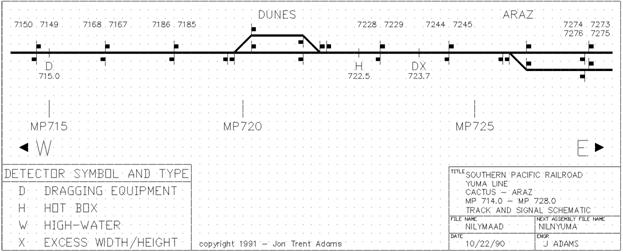
360' AMSL; +0.0% EB 714.9 Block Signals: EB 7150 - WB 7149 715.0 Dragging Equipment DETECTOR
360' AMSL; -0.2% EB 715.7 The American Girl Mine provides the name
to a little canyon on the west side of the Cargo Muchachos, from whence
this wash issues. 716.0 350' AMSL; -0.2% EB 716.4 Paved To the west (compass northwest) the trackside
access road is unpaved, hard-packed dirt. To the east (compass southeast) the county
maintains the road to the
"Not A Through Road" Little do they know. 716.6 Old OGILBY Station
Track Access Road veers south
The county road swings away from the railroad
tracks and passes near the boundary of the Little endures of the townsite of Ogilby
except the cemetery and a few bits and pieces of refuse. Track access from the north side of the
railroad is a bit more limited; the Ted Kipf Road intersects with Ogilby
Road about 0.3 miles north of the railroad and provides a firm, well-graded
dirt path paralleling the railroad all the way to State Route 78 at
Glamis. It, however, remains about 0.3 miles away
from the tracks the whole distance. 716.7 Block Signals: EB 7168 - WB 7167
SP Communications Shack and Tower So many vandals; so little intellegence.
This radio site has been wrecked more than once by the roving
hordes. It supports train communications along
this portion of desert. This
radio is linked into the 716.8 Gold Rock MCI Facility The Gold Rock MCI Facility consists of
two BLM-tan buildings behind the concertina-fenced compound along the
south side of the line. MCI
leases a portion of the Espee right-of-way and runs buried fiber-optic
cable carrying telephone communications across the country along this
route. Similar MCI facilities are located at Cherry
Valley (MP561.7), Indio (MP611.4) and Niland (MP662.4). 717.0 340' AMSL; -0.1% EB 717.7 70' Concrete/Wooden Bridge over Padre Madre
This wash carries flow from out of the
718.0 335' AMSL; -0.1% EB The Ogilby Hills are the bleak, tan, rocky,
barren low ridge and minor peaks about a mile northeast of the tracks.
The highest point is on the northwestern hill at 782 feet AMSL.
The 718.6 Block Signals: EB 7186 - WB 7185 719.0 335' AMSL; -0.5% EB 719.4 This wash originates near the Cargo Mine,
which is hidden in a small canyon on the south face of 719.9 West Switch DUNES Siding
EB/WB Absolute Signals
Siding Length 8406' 720.0 Power Lines cross Tracks
310' AMSL; -0.2% EB 720.1 West-facing Unmarked Spur A two-hundred-foot-long equipment spur
connects on the north side of the siding.
The spur is in poor repair but probably isn't used very often. Although there is a clean red target attached
to the switch stand mast, there is no track number stenciled upon it. 720.7 DUNES Station 720.9 Jackson Gulch is a major drainage off 721.0 Signpost EB 50 MPH
300' AMSL; -0.1% EB 721.6 East Switch DUNES Siding
EB/WB Absolute Signals 722.0 295' AMSL; -0.2% EB 722.5 Hot Box DETECTOR 722.7 Old KNOB Station Knob siding was about 5700-feet long, as
indicated by the 1954 timetable. 722.8 Block Signals: EB 7228 - WB 7229 723.0 Signpost WB 70 - 79 MPH
Speed Limit: EB 50 MPH; WB 79-70 MPH
285' AMSL; -0.7% EB The railroad begins in earnest its descent
from the Pilot Knob Mesa toward the Sidewinder Road is a north-south, somewhat-paved
road that connects this area to Interstate 8 about a half-mile south.
To the north, it leads to a few ranchitos and the power lines
that parallel the railroad two miles north; eventually it connects to
the " The access road along the south side of
the tracks continues both to the east and west. To the west, the road is solid, nearly
a freeway, to at least Ogilby Road (MP716.6). To the east, however, it might be unwise
to try to drive all the way to 723.7 High/Wide - Dragging Equipment DETECTOR There are two of these excess-dimensions
detectors in the area, but this is the only one in the Yuma Sub. The next one is about 16 miles east between
East Yard and Fortuna Siding. This detector consists of a large metal
frame that spans the right-of-way, with light beams and photoelectric
sensors. It attempts to
measure whether trains that roll through have loads that stick out more
than 98" from the track center or are more than 200" high. If a load has shifted much more than within
these narrow limits, the High/Wide detector gets destroyed too. 723.9 Trackside Shanty (Abandoned)
Agricultural Inspection Station on Interstate 8 The tracks border the north side of Interstate
8 for the next 1.4 miles - passage on this road west to east is probably
ok, but east to west the CHP may get the idea that you're running drugs
or illicit vegetables... 724.0
245' AMSL; -0.2% EB 724.4 Block Signals: EB 7244 - WB 7245
Entering The Yuma Indians own most all of the land
from this point to the west bank of the 724.7 Paved Access Road Begins The paved access road that rests between
the railroad and Interstate 8 is the remains of the original two-lane
highway that linked the Imperial Valley with To the west the road is barricaded with
dirt berms, ostensibly to force all westward traffic to use the Interstate
so that the Inspectors can have a chat. 725.0 235' AMSL; -0.7% EB 725.3 Access road / The access road intersects Andrade was a station on the old SP line
that separated from the mainline near Araz Junction, more or less where
Araz Switch is now. This
branch, built in the teens, allowed more direct access to the Imperial
Valley from the east by winding through The local offramp from eastbound Interstate
8 is called 725.4 50' The Araz Hills are a severely eroded badlands,
the remnants of the old alluvial fan of the south shoulder of the Cargo
Muchachos. The railroad
cuts across the trend of the north-south washes streaming down from
this range. Note that the soil along the right-of-way
is soft and loamy; although it might not trap a car, the unwary driver
could get into trouble. 725.7 50'
Two Powerlines 725.8 ARAZ Switch
EB Absolute Signals
End Single Main Track Centralized Traffic Control (CTC)
Begin Two Main Track Centralized Traffic Control (CTC) 725.9 WB Absolute Signal #1 (north) Track 726.0 200' AMSL; -0.7% EB 726.1 Old ARAZ Junction
WB Absolute Signal Tower #2 (south) Track
100' At one time this was called Araz Junction,
since the Imperial Valley Branch separated from the mainline here and
headed south. This branch
was pushed for by An interesting note: a 1923 timetable indicates
that the travel time from Araz Wash is a major drainage from the
Cargo Muchacho Mountains and more locally from the Araz Hills; a broad,
flat-bottomed arroyo, it courses from north to south, crossing under
the railroad and continuing to its eventual fate as a tributary to the
Colorado River less than a mile south. 726.3 Bridge over the The Built in the 1910s as a replacement to
the The railroad bridge does not include room
for the trackside access road; the The bluffs on either side of the canal
are great locations for watching and photographing trains climbing out
of or dropping down onto the A beautiful, graceful catenary supports
a natural gas pipeline suspended across the Canal. 726.4 Access to Tracks from A cluster of shade trees in a oval-shaped
bowl separate the railroad from The railroad continues to snake its way
down through the final reaches of the Araz Hills on its way to the The stark contrast between the eroded,
tan and ochre badlands and the trains and their consists make for good
photographs.
727.0 Old ARAZ Station
Signpost EB 60 MPH
Speed Limit: EB 60 MPH; WB 50 MPH
160' AMSL; -0.6% EB Immediately ahead the railroad leaves the
foot of the Araz Hills and forges out onto the The Araz station was along the south side
of the railroad, right in the hollow just east of the rise. A couple of shade trees are all that remains... 727.3 727.6 Tenino Lateral Irrigation Ditch Culvert Water in the Tenino Lateral comes from
the 728.0 130' AMSL; +0.0% EB 728.3 Bridge over Quick Road begins at A dirt path along the south side of the
railroad provides passage both east and west. The path east continues to MP729.0 while
the trail west provides a useable route for several miles to the
729.0 WINTERHAVEN Crossover
130' AMSL; +0.0% EB The Winterhaven Crossover allows eastbound
traffic to move from the #1 (north) track to the #2 (south) track and
vice-versa. The railroad
remains perched on top of a wide, high embankment that provides a good
vantage point for the area. The
speed limit through the crossover (going from one track to the other)
is 35 MPH. A path from the west along the south side
of the rails at the bottom of the embankment dead-ends here at a rotted-out
wooden bridge over an irrigation ditch. 729.7 Bridge over 729.9 Dragging Equipment DETECTOR 730.0 134' AMSL; +0.0% EB 730.5 730.8
Community of Winterhaven Access along the south side of tracks continues
east but the surface is very, very silty. Your vehicle must have a broad footprint
or it will sink! Access
to the west is available along the paved road on the south side of the
tracks. No access is possible along the north side
of the tracks. The central part of the community of Winterhaven
is on The railroad begins a gradual curve to
the south. 731.0 135' AMSL; +0.0% EB 731.5 30' The railroad bridge over the Canal carries
only the tracks and makes no room for non-flanged wheel traffic. To continue east, follow the Canal road
south to paved 731.6 30' 731.7 Remains of West Leg of Wye A long time ago (well, maybe not so long
ago), there was a wye along the north side of the mainline and the west
leg of that wye joined the line here.
The wye led to a branch line that went north to Laguna and later
Imperial Dams, primarily used as a construction railway.
(Perhaps called the "Potholes" branch?) 731.8 Abandoned Mainline separates south Until 1925, when the present steel bridge
over the Colorado was finally opened to rail traffic, the only way across
the river was via a wooden trestle bridge that lay just about immediately
south, at the foot of Madison Street in Yuma. The tracks veered south at this point and
followed the dike (the remains can still be seen) to the bridge. In 1964, this approach to Directly to the north of the right-of-way,
at about MP731.9, is the 731.9 Old 732.0 Signpost WB 60 MPH
EB
Site of East Leg of Wye
135' AMSL; +0.2% EB The east leg of the branchline to Laguna
Dam joined the main just west of the foot of the hill. Atop the hill used to be the site of military
The hilltop is now occupied by the Saint
Thomas Yuma Indian Mission and San Pasqual School. The tracks go through a low, rocky cut
just before the Colorado Switch. 732.1
WB Absolute Signals
End Two Main Track Centralized Traffic Control (CTC)
Begin Single Track Centralized Traffic Control (CTC)
Abandoned
Speed Limit: EB 25 MPH; WB 60 MPH The railroad narrows down to one track
for its crossing of the Along the south side of the tracks are
the remains of the Colorado station; a mainly open building about 100
feet long, it now plays host to the occasional vagrant or bunch of kids
drinking and whooping it up. 732.4 500' Welcome to Completed in 1923 but put into service
in 1926, this fine example of a Both ends of the bridge display "No
Trespassing - SPT Co." signs.
The bridge really isn't wide enough to accommodate both pedestrians
and trains at the same time. 732.5 Enter See the next section for details. |