|
SECTION I
THE YUMA DISTRICT: AN INTRODUCTION
Welcome to the Yuma District
The Southern Pacific Lines, comprised of the rails of
the Southern Pacific Transportation and the Denver and Rio Grande Western Railroad Companies,
join 15 states with over 15,000 route-miles of railroad, the largest
percentage of which lies in the Golden State of California. The Los Angeles
and West Colton Divisions contain 10 percent or 1500 miles of those
routes, spanning from the Arizona border
to the central California
coast.
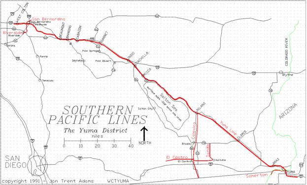
The Yuma District is one of five in the West Colton
Division; it extends from West Colton,
California to Yuma,
Arizona. The Yuma Line is the major artery under
the control of the District, with the San Bernardino
and Riverside branches serving the Inland
Empire area while the Calexico, Sandia, El Centro
and Yuma Valley Railroad branches support the transportation needs of
the Imperial and Yuma Valleys
in Arizona and southeastern California.
In the past, the Yuma District has been called the Yuma
Subdivision; the SP seems to change the appellation back and forth over
time.
The Reason for a Guidebook
What is the purpose of this guidebook? It's to assist the SP rail enthusiast,
the railroad modeler, perhaps even the occasional SP employee to have
a better sense of feel for the Yuma District and the country through
which the railroad passes. It's
for the armchair railfan, for the folks who would rather not fight the
traffic, the desert, the heat.
It's for the railroaders who for whatever reason can't get to
the Yuma District, whether because of distance, money, health, or bad
tires.
This guidebook attempts to provide an general overview
of the railroad as it existed in 1990. I tried to pay attention to detail so that,
as I said before, if you're not able to get out and about the Yuma District,
that by reading this you'll still get a good feel for the railroad and
its physical plant.
Guidebook Format
The guidelines that are set forth in the following paragraphs
are exactly that; these are the rules of observation and reporting that
I attempt to follow while researching the
railroad. They
will also help to explain features of the book and the methods for measurement
and recording.
What To Include in a Guidebook
A difficult problem was what to make note of and what
to ignore. I hope that I
have recalled all the pertinent details and left out most of the chaff. In areas where there is a dense population
of railroad features (signals, switches, bridges, grade crossings) this
isn't a problem. There is
always something to write about and there are plenty of landmarks and
points of interest for the reader.
But in the stretches of spare country, like between GLAMIS (MP698.1)
and CACTUS (MP712.3), there are few landmarks to go by and so I will
pay a bit more attention to minor drainages, power lines and dirt roads.
Data Collection Techniques
Like many of you, I have spent weekends cruising the
Tehachapi Loop, checking out the Lone Pine Branch (Trona Line), waiting
atop the Pepper Street Bridge at the east end of the Departure Yard
at West Colton, watching the action or the lack thereof.
I noticed that many others seemed to do the same thing, and that
everyone had their own secrets to successful railfanning.
I found no source of information that really described
the railroad at the detail that I desired, especially out in the forbidding
reaches of the Yuma Line. So
I began to write down everything that I saw or heard, whether from railfans
or railroaders. I used a
microcassette recorder to capture on tape many bits of information that
were too fleeting to stop the car and write down.
In all, compilation of this Guide has cost at least
several hundred hours of time in the field, a few dollars in repairs
to my car, and probably a failed relationship or two in my personal
life.
Explanation Of Descriptions
Being of moderately well-ordered mind, it seems apparent
that a sensible method of constructing a Guide is to write one that
uses the nearly ubiquitous Milepost as the index. So this Guide starts at the lowest Milepost
on a route, and proceeds upward.
By definition, this is always eastbound, although it's sometimes
less than apparent that the rails are going anywhere near eastbound.
Location names are printed in CAPITAL letters for three
reasons. The first reason
is that it may be a station or siding and so is called out in the Southern
Pacific Western Region Timetable dated October 1987. Second, it may also signify a name of a
specific place referred to by either train crews or by the dispatcher. An example of the first instance is "the
west switch of North GARNET Siding"; Garnet siding is described
in the Timetable. Of course,
the third reason is that the reader can see it that much more easily
during a quick scan of the manual.
A fine example of the second occurrence is the BLYTHE
CROSSING (MP612.9); this is actually where Dillon Road crosses the railroad tracks
at the southeast end of Indio. Although not called out in the Timetable,
SP crews near the Dillon Road grade crossing will sometimes call out
this name where asked for a location by other crews working in the same
area. Why? Because along Highway 86, parallel to the
railroad, there is a highway sign indicating to automobile drivers and
also visible to the train crews, that the town of Blythe is "thataway"
down Dillon Road.
Almost all switches not directly coupled into the main
track will have a number stenciled on their target. This number refers to the spur that the
switch controls and not to the switch itself. Examples of this are the interchange tracks
at Niland: The same numbers are on the switch targets at either end
of the track (tracks 0592, 0593 or 0594).
So technically the switch labeled 0594 at around MP666.9 would
be described as "the switch (or turnout) at the west end of 594". But in some cases the spur is single-ended,
and therefore there is only one switch target with that number, as exists
at the equipment spur 1145 near the west end of Glamis siding. The point is that although the number is
specific only to the spur track I will use that number to refer to either
the switch or the spur; the text description will (hopefully) clarify
the reference.
Routes
The Yuma District consists of the Yuma Line and six
branch lines that act as feeders.
The Yuma Line is the primary portion of track in the District,
and certainly the most important freight route and through route for
the traffic coming from the west coast and headed to the southeast and
east; depending on season, the southern route can be safer, faster and
more reliable than the central route through Nevada,
Utah and into Colorado.
The guidebook stresses operations on the Yuma Line,
with auxiliary chapters on the various branch lines within the District.
Mileposts
The guidebook is organized by milepost: the guide begins
with the lowest milepost number and, in the case of the SP, travels
eastbound. I have made numerous
trips along the right-of-ways in both directions, and I debated at some
length as to how I could construct a book that could be read either
east to west or west to east. I
looked at other types of guides that I have seen in the past; I could
see no simple way to present a bi-directional trip log.
If you intend to travel the route east to west, then you'll have
to read backwards, just like me.
Mileposts along the SP are almost always marked with
a milepost sign. Sometimes
a trackside signal line pole doubles as the post, but often there is
a special pole devoted to milepost duty, sitting all alone, perhaps
even on the opposite side of the tracks from the signal line poles. In a few instances, the milepost sign (the
number board) is missing, but on these occasions you can usually recognize
the post since the lower half of the post itself is painted white. If the whole post is missing, you'll have
to rely upon your odometer or upon the "count the poles" method.
The signal line poles along the right-of-way support
power, control and signal wires that carry the commands that the dispatcher
issues to operate the railroad.
There are, on average, about thirty-three poles per mile. Depending on the soil type, weather conditions
and such there may be more or less; the minimum number I have counted
between mileposts is twenty-five and the maximum nearly forty.
While wandering around along the right-of-way, I will
often use these poles to estimate my position with respect to the mileposts.
For instance, if the number of poles per mile has been averaging
30, the distance covered by three poles is about 0.1 mile.
This comes in handy when you find that your odometer is inaccurate
or there are few culverts or bridges with stenciled markings indicating
their locations.
I could have used pole count for the distances as described
in this book: for instance, the bridge at MP673.7 I could have described
as MP673+27, where 27 is the number of poles east of the 673 milepost
marker. Although it might
have been of some added ease for a few people, I realized that the majority
would prefer the locations given in actual miles, so that most could
consult maps without necessarily having to have been there.
However, some of the distances I measured in making up this guide
are based upon pole count.
Measurement Accuracy
The accuracy of my measurements is about 0.1 mile; therefore
I do not display more precision than that. I always round down to the previous 0.1
mile. The bridge that crosses
the American Girl Wash has the location 715.78 stenciled upon the abutment;
I will include this bridge in the list of items for the milepost 715.7.
Often there are multiple items of interest in a given
tenth mile; generally the guide book will always list the features in
order of location. However,
the most predominate railroad features in that tenth mile will always
get top billing over any other observations, with the following text
clarifying the order of appearance.
An example is the following listing from Milepost 576.5:
576.5 MONS
Crossovers
East Switch Mons
Siding
West Switch Fingal Siding
EB/WB Absolute
Signal Towers
Colorado River Aqueduct Crossing
Fingal Siding Length 11373'
The most important structure is the Mons Crossover itself,
followed closely by the fact that this location is the east end of the
Mons Siding and the west end of the Fingal Siding; there are signal
bridges at either end of the crossover.
Lastly, the Colorado River Aqueduct that supplies the majority
of water to Southern California passes under the tracks just a few dozen
feet west of the west end of the Crossover.
Also note that there are a few irregularities concerning
the mileposts: the tracks cross Mammoth Wash on a 200' bridge with the
marked location of 679.98; however, the 680 milepost is immediately
west of the bridge. Therefore
sometimes the mile markers aren't exactly where they should be. Often it will seem that the distance between
mileposts is not exactly 1.00 miles. It rarely is.
Mysterious Alphanumerics
OK. So you
read that MP552.7 is the site of the EL CASCO Station. Then immediately after that entry, the
mysterious "RIV9BB6" appears.
What's that, you ask?
I had to standardize on some set of maps for the reader
to begin with. The United
States Geological Survey topographical maps (topos) are a wonderful
trove of invaluable mapping information, but aren't generally much good
as day-to-day highway maps. Since
the Automobile Club of Southern California is not in the habit of distributing
their fine maps to the general public, the next best are the publications
of the Thomas Bros. Map Company and the DeLorme Company.
Both companies provide a set of mapbooks that cover
all of California
in varying levels of detail. "RIV"
refers to the Thomas
Bros. Riverside
County mapbook;
"9B" is the mapbook page, "B6" are the x-y coordinates
on that mapbook page. The
combination of the Thomas Bros. "Riverside & San Bernardino
Counties Street Guide and Directory" can get you in reasonable
detail all the way to about Ferrum Station at MP639.
From there, the "Southern California Atlas and Gazetteer"
published by DeLorme provides reduced resolution and detail all the
way to the Colorado River and Yuma
and to well beyond MP740.
Errors, Corrections and Plain Untruths
Most all of the field observations taken for this Guidebook
were made between March 1989 and May 1991. I have strived to report accurately all
the information in this Guide and have attempted to keep the errors
to a minimum since there is little advantage to me to fabricate untruths. I have no affiliation with the Southern
Pacific, except as an interested observer and have no secret hot line
to the people in the know. In
fact, as was mentioned in the book The Southern Pacific, 1901 - 1985
and from personal communications with SP employees, much of the history
of the company is lost to the company.
What remains rests outside the company and in the minds of the
employees and retirees of the railroad.
Since the Southern Pacific is a living, dynamic entity,
there will be regular changes and modifications to its equipment and
physical plant, and what is in evidence one day may be nothing more
than a bit of subroadbed or a few scattered ties a month later. I therefore cannot guarantee anything more
than that I have made an honest attempt at reporting.
I welcome any information from readers that helps to
clear misunderstandings that I might have inadvertently caused. I also hope that those with additional
information about the railroad's history in this region will come forth
so that it may be included in any future editions (Hope Springs Eternal)
of this Guide. In fact,
I hope that there will be subsequent editions that cover other portions
of the Southern Pacific Lines, the Santa
Fe and other interesting railroads.
Reference Materials Used for this Guide
There is obviously no one book that has provided me
with the information that this book contains. (If there was, I would have bought it instead
of writing this). Of course
much of what is detailed here is through field work: personal reconnaissance,
talking with railroad employees, camping out along the route and watching
the traffic. Books about
railroading, California history, general
history, geology and geography, and newspaper articles pulled off microfilm
from a storage vault provide more input and breadth. The last and equally important are the
maps: old maps from a variety of sources printed over the last hundred
and fifty years, United States Geological Survey (USGS) Topographic
(Topo) maps, Defense Mapping Agency Maps, maps published by the Automobile
Club of Southern California, Thomas Bros. maps, freebie maps given out
by developers and museums, etc.
All maps that I had available to me have provided some input,
directly or indirectly, to the formation of this Guide.
The following is a partial list indicating the major
references used. The list
is not exhaustive, and I'm sure that there are many references that
I never saw that might provide me with a clearer picture.
Publications
"Western Region Timetable 2", Southern
Pacific Transportation Company, October 25, 1987
"Western Region Timetable 3", Southern
Pacific Transportation Company, October 29, 1989
"All About Signals", John Armstrong,
Kalmbach Publishing Co., 1957
"Trackwork Handbook", Paul Mallery,
Boynton and Assoc., 1977
"The History of The Southern Pacific",
Bill Yeane, Bison Books, 1985
"The Southern Pacific, 1901 - 1985",
Don L. Hofsommer,
Texas A&M Press, 1986
"Southern Pacific Country", Donald
Sims, Trans-Anglo Books, 1987
"Santa
Fe' Route To the Pacific.", Philip
C. Serpico, Omni Publications, 1988
"San Diego
and Arizona
Eastern", Robert Hanft, Trans-Anglo Books, 1984
"City-Makers", Remi Nadeau, Trans-Anglo
Books, 1955
Trains Magazine, CTC Board, Pacific Rail News, Various Issues
"Flimsies! The Newsmagazine of Western Railroading",
many issues
"The History of California", H. H. Bancroft, 1883,
Vol 1-7
"The Compendium of Signals", R. F.
Karl, The Builder's Compendium, Celeron,
NY, 1971
"The Southern California
Guide to Railroad Communications", James Ciardi, 1987
"Railroads of Arizona, Vol. 1", D. Myrick, Trans-Anglo, 1975
Unpublished List of Railroad Frequencies, Greg Ramsey
/ Brian Hunell, 1990
Mapbooks
and Maps
"Early California
Atlas - Southern Edition", R. N. Preston, Binford & Mort
Publishing, 1988
"San Bernardino & Riverside Counties Street
Guide & Directory", Thomas Bros. Maps, 1987
"California
- Road Atlas and Driver's Guide", Thomas Bros. Maps, 1988
"Southern California
Atlas and Gazetteer", DeLorme Publishing, 1986
"Los Angeles
and Vicinity", Automobile Club of Southern
California, May 1986
"Riverside
County", Automobile
Club of Southern California, March 1988
"San Bernardino
County", Automobile
Club of Southern California, June 1988
"Imperial
County", Automobile
Club of Southern California, June 1988
"Salton Sea", Kym's Guide, Triumph
Press, Los Angeles
1986
United States Geological Survey, 7-1/2 and 15 minute
maps
SECTION II
A POCKETBOOK HISTORY AND GEOGRAPHY OF THE
YUMA DISTRICT
Introduction
The Southern Pacific Transportation Company (SP) spans
15 states with 17,000 route-miles of track - a western transportation
colossus. Since its earliest
beginnings in 1850 as the Buffalo Bayou, Brazos and Colorado Railroad
serving southeast Texas,
the SP has formed an irreplaceable and historic link in the chain that
has given the West its strength.
The Southern Pacific In Southern
California: The Sunset Route
The history of the SP in California
begins in 1865 with the incorporation of the Southern Pacific Railroad,
its mission to unite the cities of San Francisco
and San Diego, meeting the Texas
and Pacific at San Diego,
to complete a second transcontinental railroad. A second railroad spanning the continent
came about as a result of this, but history would see that the Texas and Pacific was never
involved. This railroad
was to be the creation of the Southern Pacific, through its lessees,
all the way to New Orleans.
By 1874, the SP, which had known for some time the economic
importance of building a second, southern route across the country,
began to actually undertake the task.
This route would take the railroad south through California's
San Joaquin Valley,
up over the rugged Tehachapi Mountains, across the Mojave Desert and
down through Cajon
Pass. From San Bernardino, the rails would turn
east and forge across the Coachella and Imperial Valleys, cross the
Colorado River at Yuma, Arizona, and continue eastward through Tucson
to El Paso, Texas. The stretch
across Texas to Houston and New Orleans would be under the banner of the Galveston, Harrisburg and
San Antonio (GH&SA) and the Texas
and New Orleans
(T&NO) railroads.
Politics in Southern California put a detour in this
most direct route; soon by congressional order the SP would be required
to abandon its route over the Cajon
Pass and instead drop into Los Angeles
via Soledad Pass, entering the Los Angeles
Basin at San Fernando. The citizens of Los Angeles had no desire to be on a hinterland
branch line of such an important railroad and by this Congressional
action they were able to coerce the railroad.
The year 1875 saw the Southern Pacific building down
the San Joaquin Valley
toward the Tehachapis; at the same time, an unconnected piece of SP
track was built in the Los Angeles area
from San Fernando to Spadra, near Pomona.
It would not be until 1876 that these two pieces of railroad
would connect at Lang, near the bottom of Soledad
Canyon, northeast of San Fernando.
Now that SP had grudgingly completed its involuntary
patronage of Los Angeles,
it turned its sights east again.
Beginning at the Spadra terminus, gangs laid track eastward toward
San Bernardino in 1876.
Negotiations with the city of San Bernardino
failed to produce any sort of monetary or real concessions for the railroad;
therefore, SP decided to avoid San Bernardino and created the new town of Colton, named after David
Colton of the Southern Pacific Company.
By fall of 1876 the railroad had made it up through
San Timoteo Canyon, south of Redlands,
and had begun the descent into the Salton Sink. Track building across the Coachella Valley
and the northeastern edge of the Imperial Valley
continued throughout the end of 1876 and into 1877.
The remaining miles across the southeastern tip of California were covered
during the summer of 1877. Soon
the railroad had arrived at the west bank of the Colorado River, immediately
across from the military outpost of Fort
Yuma, across the river in the Arizona Territory.
The Colorado River
was not the only barrier to further eastward progress. The Southern Pacific did not yet have congressional
authorization to proceed east into the Arizona Territory
and so the governor of the Territory forbade SP from bridging the river.
One story of the conquering of Yuma, told by Bill Yenne in his The History
of the Southern Pacific, involves the liberal use of whiskey. The SP threw a grand celebration under
a pretense; all the soldiers from Fort
Yuma were invited
to the bash. The soldiers
proceeded to drink heartily for some five days.
With the Fort out of commission, bridge-building and track-laying
crews spanned the river and laid track into Yuma.
By the time the soldiers had sobered up sufficiently,
the SP was established in Yuma. Although the governor attempted to force
them out, the local citizenry, enthusiastic with the coming of the railroad,
raised a vociferous protest which caused, in short order, the approval
of the SP action by the Territory and allowed for the continued eastward
progress of the railroad. The
Southern Pacific had won the war.
(However colorful this tale is, I suspect that reality
was a bit more monochrome, especially since there were only a few soldiers
stationed at Fort
Yuma; I repeat
it here because it's a cute story.)
By 1881 the railhead was at El Paso.
SP's corporate cousin, the GH&SA out of San
Antonio, was instructed to build west to meet with eastbound
Southern Pacific crews laying railroad out of El Paso.
In 1883 the rails met at the Pecos
River, nearly 300 miles east
of El Paso. The Sunset Route was complete - the second
transcontinental railroad finished.
GEOGRAPHY AND GEOLOGY: The Setting for The Yuma Line
One hundred and ninety-five miles of some of the most
exceptional land on the planet separate West Colton,
California, from Yuma, Arizona. The whole country is shaped by planetary
geotectonic forces that manifest themselves as the San Andreas Fault
Zone, a thousand-mile-long crack in the Earth's crust separating the
North American and the Pacific crustal plates.
Los Angeles and the southern coast of California
are attached to the Pacific Plate while most of the rest of North
America rides upon the North American Plate.
The Pacific plate is inching its way north relative
to the North American Plate, and this movement over millions of years
has created the high mountains of the San Bernardino
and San Jacinto
Ranges, along with the deep, arid trough
of the Salton Sink. Few
other places on the planet have such differing environmental conditions
within the space of a few miles as southeastern California.
The Southern Pacific Railroad leaves West Colton, high
on the western bank of the Santa
Ana River;
the rails cross the river five miles east and one hundred twenty-five
feet lower in elevation. At
the river crossing, the railroad is approximately 950 feet above mean
sea level (AMSL). East from
the river crossing the route climbs through Loma Linda and into the
San Timoteo Canyon, the major drainage from the San Timoteo Badlands,
themselves a wrinkled artifact of the busy San
Andreas fault system.
This canyon provides the only reasonable access to the San Gorgonio
Pass, a 2600' Above Mean Sea Level (AMSL) saddle between the 10,804'
Mount San Jacinto and 11,503' San Gorgonio Peak, lying south and north
of the eastward-trending pass and a mere 21 miles apart.
The railroad passes through the town of Beaumont, at
the top of the pass, and drops into Banning, then Cabazon and finally
West Palm Springs before reaching the Coachella Valley floor at Garnet,
about seven miles north of Palm Springs.
The eastern descent from the pass follows closely the drainage
of the San Gorgonio and Whitewater rivers.
The Coachella and Imperial
Valleys define the bottom of
the Salton Sink, with the man-made Salton Sea
currently covering the deepest portion of the sink. The railroad continues southeast from Garnet,
easing down from about 680' AMSL to sea level at the outskirts of Indio, following a near
straight-line path first surveyed over a hundred years ago and now sheltered
from the wind and sand by towering groves of tamarisk trees.
Indio is about 15' below sea level; the rails continue southeast
through Coachella, then Thermal and Mecca,
before bending around the eastern flank of the Salton Sea, where the
railroad is fully 200 feet below sea level. The SP qualifies for the sole honor of
being the railroad built furthest below sea level - the next closest
are railroads (if any) built to waterfront on the Caspian Sea in central
Russia, at a depth
of 92' below sea level. But
at the onset, the SP rails sank even deeper.
The Salton Sea
The Salton Sink has suffered repeated bouts of natural
flooding from the Colorado River. Lake Cahuilla
is the name of the ancient, natural body of water that has occasionally
occupied the Sink; the highest recorded shoreline for this lake was
44 feet above sea level. This
is known because the lake rested at this level long enough for the wind-generated
waves to cut significant benches into the surrounding countryside at
the 44-foot level.
The Salton Sea is a modern analog of Lake Cahuilla
and an artifact of man's existence in southeastern California. In 1901, land speculators and a few major
property holders created the California Development Company, the goal
of which was to bring Colorado River water to the parched but fertile
soil of the Imperial Valley. An
experienced canal-builder and real estate speculator from Los Angeles joined the effort and designed and engineered
the Alamo Canal,
tapping the waters of the Colorado River and bringing them through the
Mexican desert into the Imperial Valley,
a distance of nearly seventy miles.
This proved to be a tremendous boon to the region; the
soil was extremely rich and the climate allowed year-round growing cycles.
The plentiful water from the Colorado
allowed the land, along with the developers' pocketbooks, to blossom. But all was not well. The speculators had dug the canal cheaply,
and had not concerned themselves with the vagaries of the river. Several times in the following few years
the headgates of the canal suffered minor damage due to flood flow on
the Colorado; in 1905 the river succeeded in breaching the inadequate
structure and quickly the rushing water carved a path nearly a half-mile
wide and carrying nearly the full flow of the Colorado.
The Salton Sea was reborn.
The railroad had originally gone south-southeast from
Mecca,
made the sweeping bend east and then angled back to the southeast near
the townsite of Salton. The
tracks continued down through the depths of the sink until well south
of current Bombay Beach;
here the line fell to nearly 270 feet below sea level. The rails turned southeast again and headed
straight toward Niland, back to its present-day course.
The task of the repair of the break and the plugging
of the flow would fall to the Southern Pacific. They would spend two years and over twenty
million dollars, and would have to move their right-of-way through the
sink several times in a constant retreat from the rising water level
in the Sea. In 1907 the flood was finally halted; the
Salton Sea stood at 210 feet below
sea level. Evaporation and
inflow from the farming operations in the valley have stabilized the
surface at about -228 feet.
There is apparently no evidence remaining of the original
route. The current route
follows the 200 foot contour line around the south side of the Bat Cave
Buttes, heading northeast before turning once again to the southeast
at Frink Siding.
The Imperial Valley
The Salton Sea rests at the north end of the Imperial
Valley, filling most of the valley floor remaining between the Santa Rosa Mountains
on the west and the Orocopia
Mountains on the
east.
Over the past few millenia, the Salton Sink has suffered
repeated flooding, making a vast inland sea that would slowly evaporate,
only to be repeated again. But
quite regularly this land would be well below the surface of this saline
lake.
The Bat Cave Buttes and the Salt Creek Wash between
Ferrum and Bertram sidings are eerie, incredible examples of what the
floor of the sea is like. Hiking
around there, the ground is smooth, eroded and clay-coated, with every
handful of dirt producing a dozen tiny shells of the various sea creatures
that lived in this lake.
From Wister, the railroad begins the climb out of the
bottom of the sink and passes through Niland, about 150 feet below sea
level. The tracks continue
the gentle climb up the bottom of this ancient lake toward the ancient
shoreline, just west of MP676.
Obvious signs of the approaching shoreline and beach happen at
about MP675.3 where the rails cut through a ridge; atop this ridge is
where waves broke on an ancient beach.
The land beyond the shoreline is the East Mesa; the railroad continues southeast along this plateau,
skirting the northern tip of the Sand Hills, themselves a result of
the strong easterly winds blowing the fine sand from the bottom of the
Sink. The rugged Chocolate Mountains
and the Cargo
Muchacho Mountains
define the eastern edge of the valley through which the tracks pass. The western side is bounded by the Sand
Hills.
South of Glamis the railroad continues onto the Pilot
Knob Mesa; in the far distance the spire of Pilot Knob itself is visible
and the tracks will aim at this mountain for the next twenty miles. All the drainages from the mountains along
the east carry stormwater into the natural sink of the Sand Hills in
the west; these flows can be heavy as is evidenced by the number and
size of the culverts passing under the roadbed.
The Yuma
Valley
Just past Dunes at MP723 the path bends east and begins
the descent toward the Colorado River; the rails pass across the south
shoulder of the broad alluvial fan emanating from the Cargo Muchacho
Mountains, using
cut and fill to cross the multiple south-trending gullies and washes. The final few miles to Araz switch are
followed by the double main track that snakes down the remainder of
the alluvial ridge, crossing the All-American
Canal and riding
out promptly onto the broad floodplain.
The tracks continue east on a high embankment across
the fertile, irrigated farmlands of Winterhaven; the Winterhaven crossover
rests upon this fill which can reach a height of some thirty feet.
The railroad originally crossed the Colorado River about
a half-mile west of the current steel bridge; the alignment took the
rails across the river and down the center of Madison Street in Yuma, Arizona. Today, evidence of this path has faded,
with a few sections of embankment on the California
side and a broad open swath running through the middle of Yuma's downtown district. In 1926 the modern steel bridge was opened
to traffic, anchored in the two hills that act as a gate for the Colorado River.
The Yuma railroad station
is situated about 0.5 miles south of the crossing at MP732.7 and is
the crew change point and is technically the meeting point for the Los
Angeles (now West Colton)
and Tucson Divisions. In
actuality, the West Colton Division maintains jurisdiction of the railroad
all the way to the division marker at MP738.8 as part of the Yuma District.
Sightseeing the Yuma District: Driving Out There
The railroad for most of its entire distance is bounded
either on the north or south by an access road. In general the placement of important equipment
like signal boxes and signals will be on the same side of the tracks
as the road. This way signalmen
and other maintenance-of-way folks needn't cross the tracks to get to
most of the equipment. This
road is usually the main route and sometimes the only way for rubber-tired
vehicles to have access to the rails. It can be rather rough, and very
tough on a vehicle.
There is no single proper vehicle for getting to 99%
of the locations addressed in this book.
The family sedan will work as well as a high-clearance four-wheel-drive
truck with big tires and little Chromium Cuties on the mudflaps. The patience, skill and plain daring of
the driver count for a lot.
Ground surfaces vary from paved road to gravel to loamy
soil to sand to rock flour to sheer, unadulterated glop. All but the last are approachable in the
family car (unless you or the family car has a death wish). The most important thing is to know how
to drive for the conditions and to be prepared for the consequences
when you make a mistake. And
this is not a primer on desert driving.
I tend to do most of my sightseeing alone; I have gotten
myself buried in the dust at old Tortuga Siding, had the battery die
at Iris, almost mired in the thick powder at Colorado, stuck in sand
drifts near Salvia; trapped in the mud near Brawley, and lost automotive
trim everywhere. If you
see bits of a 1981 tan diesel Rabbit, they're probably mine. But the point remains, I've never yet not
been able to dig myself out. It's
just a matter of preparation, perspiration, persistence and maybe a
little luck.
One of my mottoes is (or should be): "When in doubt,
walk it out". In other
words, if the road ahead looks chancy, get out and check it on foot. If confidence returns upon inspection,
you might want to go onward. But
remember, getting stuck without the proper supplies is crazy. And both my lawyers and I want you to remember
that I didn't tell you to do ANYTHING. In fact, that's why I wrote this book.
So all you'd have to do is sit in a cozy armchair at home and
read.
This railroad runs through one of the hottest, driest
and most desolate pieces of desert in the Outback. Bring water. I repeat: Bring WATER. During the warmer months bring LOTS of
water, which means at least a few gallons per person per day.
Carry a two-way Citizens' Band radio. Or if you're so inclined, get yourself
a Amateur Radio License. Or
carry a cellular telephone but remember, there's not much coverage in
the backcountry. Carry a jacket for the chilly nights and
a supply of food. Buy (and
read) a book on desert survival.
But don't go out unprepared.
It's not fun when the only alternative is a ten-mile stroll in
120 degree heat.
Weather
Be prepared for extremes. Mainly high temperatures, to be sure, though
winter evenings through the San Gorgonio Pass can drop into the teens;
the air temperature on summer days east of Niland can be greater than
120 degrees Fahrenheit; the ground temperatures are much higher. I know; I've measured it. Check with the National Weather Service
or other local weather information sources before heading out; heat,
cold or thunderstorms can be problematic at best or deadly at worst.
High winds and blowing sand can especially plague the
Coachella
Valley near the mouth of the San Gorgonio
Pass; this natural sandblast can etch your car's windshield. Of course,
the fashionable residents of Palm
Desert have had
to live with this reality for a long time.
So you won't be alone.
Watch out for the extremely infrequent but very dangerous
flash floods in desert canyons and washes.
One of my friends has a personal story that details the innocuous
peals of far-off thunder followed minutes later by a large rush of water
roaring down the canyon, scouring the wash and nearly flooding his car. In August 1989 a fair bit of tracks from
the east end of south Garnet down to about Date Palm Drive suffered substantial damage
due to flooding, this out in the near flats of the Valley floor. Pay attention to where the clouds are and
where your vehicle and you are not.
Don't camp in a wash while there is any chance of rain within
sight.
SECTION III
RAILROAD PHYSICAL PLANT AND OPERATIONS
Introduction
The SP is more than a bunch of MBAs, accountants and
130 years of history; there are dozens of trains active over the district
at any time, somewhere on those 1500 route-miles of track. The physical plant is its complex, expensive
and dynamic skeleton, consisting of all the hardware that makes the
trains run, including the trains themselves.
Trackage: The Mainline
Within the Yuma District, the Yuma Line is the "main"
line that carries through traffic in the district. Beginning at West Colton at the junction
of the Basin District's Colton and Alhambra
Lines, the Yuma Line extends nearly two hundred miles southeast to Yuma, Arizona,
handing off traffic there to the Gila Line of the Tucson Division.
Much of the traffic that uses the line is either originating
or completing its journey at Los Angeles,
and often at the ICTF complex in Wilmington,
between Long Beach
and San Pedro. The remainder is through-traffic, with trains running
to and from the Bay Area and Oregon
regularly rolling up and down the Yuma Line, carrying vast assortments
of products bound for the middle of the country.
Trackage: Branchlines
There are six active branchlines within the District.
Until October 1989, the San Bernardino and Riverside
Branches were part of the Yuma District; between them there is maybe
ten miles of track. In the
Imperial Valley, the Calexico Branch separates from the
Yuma Line at Niland, leading south to the Sandia and El Centro Branches,
a total of about seventy-five route-miles.
Finally, at Yuma
the Somerton Branch (Yuma Valley Railroad) peels off from the mainline,
providing yet another six route-miles of track. All the branch routes together constitute
less than half the length of the main line within the District.
Trackage: Yards
Although there are several places along the railroad
that qualify as railroad yards, West Colton Classification Yard is the
only facility of truly massive size; from one end to the other, West
Colton stretches over five miles in length, with fueling facilities,
a hump yard, service facilities and a major administration building.
Other, much smaller and less-busy yards include Indio, Niland and Yuma;
even these only see a few movements a day.
The interchange yard at Ferrum is currently used only for storage;
El Centro sees occasional
activity.
Trackage: Trackside Detectors
Trains are mechanical beasties, and pretty tremendous
mechanical beasties at that. There's
lots of stress and strain on the rolling stock, and that impacts the
trackwork, generally in an adverse manner. And sometimes the trackwork affects the
trains. Behold the trackside
detectors.
This is a generic class of devices that replace the
folks who, back in the days when salaries were lower, were paid to sit
and watch trains all day. By
doing so they could check for jammed brake shoes causing overheated
wheels, shifted loads that could endanger employees, bystanders or trackside
equipment, etc. Of course, most all those folks are long
gone now; but the need for early problem detection remains.
There are five types of detectors used within the Yuma
Sub; these are the Dragging Equipment Detector, the Hotbox Detector,
the High Water Detector, the Barricade Detector and the High/Wide Detector.
The Dragging Equipment Detector consists of a set of
vertical steel vanes on a rotatable shaft; this shaft lies across the
tracks, underneath the rails, and is connected to a mechanical rotary
switch in a box adjacent to the rails.
The vanes reach up just to the height of the railhead, waiting
for trains to pass over. If
there are loose couplings, hoses, understructure parts or even a derailed
car, this dragging material will strike the vertical vanes and rotate
the attached shaft, causing the rotary switch to close and setting of
the dragging equipment alarm.
The Hotbox Detector is a device that is sensitive to
the infra-red energy emitted by hot objects; as a railcar passes over
the detector, the hotbox detector "looks" at each wheel and
bearing set, checking the temperature of each and setting off an alarm
if the critical threshold is exceeded.
It consists of a pair of low, angular, cast boxes that are fastened
to the tie surfaces on the outside of the rails.
The High Water Detector is a vertical pipe with an internal
float; placed in a streambed or anywhere potentially destructive amounts
of water can accumulate, the detector is triggered when the water level
rises enough to cause the float to rise in the pipe, closing a switch
and activating an alarm.
The Barricade Detector is a general name for any detector
that trips when some large item goes somewhere that it shouldn't; either
a railroad car rolling off the end of a spur track and grounding itself,
perhaps tipping and fouling the main track, or maybe an automobile or
truck running off the highway and fouling the track.
In the first case it is a heavy metal bar that is broken when
a railroad car or engine rolls past; the latter case is generally a
cable strung along a row of posts, with one end of the cable attached
to a switch that closes when the cable is pulled or broken.
The last type is the High/Wide Detector; there is exactly
one in the Yuma District, an open, metal frame that bridges the mainline
tracks near Yuma. Attached to this frame are lamps that shine
a narrow beam of light into photocells also attached to the frame. Normally, a train rolling through this
framework will not cause any of the light beams to be broken; but, if
there is a shifted load, or an item that is stacked too high, the beams
will be blocked momentarily as the train passes through the detector,
setting off the alarm.
Trackside Equipment: Signals
Signals have help control train movement on the railroads
since the 1830s. They serve
the same purpose that the signals which control your nearby highway
intersection do: to orchestrate traffic movement for added safety and
efficiency.
There are many types of signal, but nowadays most all
employ electric lamps that display various colors, with each color having
a specific meaning. Gone
(at least in the Yuma)
are the old semaphore signals with a mechanical arm that was raised
or lowered to indicate traffic movements.
The standard signals used along the SP are called searchlight
signals, with a single lamp located in the center of a single, black
target at the top of a high staff.
Color changes on these signals are effected by the internal movement
of different color filters in front of the lamp.
Sometimes, added traffic control is required, with extra
searchlight signals added to the staff at lower points. Secondary signals are often on low staffs,
with reduced-size targets. Some
secondary signals are mounted directly on the ground; these are called
"dwarf" signals and are generally used where there is limited
mechanical clearance.
Signals can be mounted on towers or bridges; throughout
the Yuma Line, and especially between West Colton and Beaumont, there is a fine
display of nearly all the possible signal mounting variations.
Bridges and Culverts
There are only three ways (in our three-dimensional
world) to allow something to get from one side of the tracks to the
other; the first is a crossing at grade, where the cross traffic blocks
the main route. The second and third are variations of
one another: the overpass and the underpass.
When it comes to water, grade crossings aren't generally
a good idea (unless it's the locomotive washing facility). At least along the Yuma Line, all water
flow passes below grade, either by flowing through a culvert or by the
tracks being carried over the water on a bridge.
Culverts mentioned in this book are generally cast-concrete
pipes, either circular or rectangular in cross-section, and usually
(but not always) a maximum of a few feet across. There is an abundance of corrugated-steel
culvert pipes used also; these will either have a circular, oval or
arch cross-section. In almost
all cases, culverts are used where a fill was cheaper than a bridge
or other large structure; the culvert provides the passageway for runoff
to flow from one side of the fill to the other.
Bridges in the Yuma
are usually wood- or steel-pile trestle structures, constructed over
low depressions and streams where the volume of water flow is enough
to make the use of a culvert questionable.
Of course, if piles can be driven securely enough, a pile-trestle
bridge is a far less-expensive method of fording a gap than is a full-fledged
truss bridge.
As far as "real" bridges in the Yuma District,
there are two of note: the Pennsylvania Truss bridge over the Colorado
River at Yuma, and the box-trestle structure
over the Salt Creek Wash east of the Salton Sea. The rest of the span bridges are deck-
and through-plate girder ones, with single-span lengths up to a hundred
feet or more.
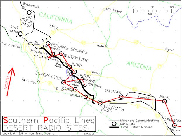
RAILROAD COMMUNICATIONS
The Southern Pacific, like all other modern railroads,
makes extensive use of the two-way radio for communications between
dispatcher and train.
All communications along the railroad are for the most
part carried on a private system of microwave-frequency radios located
at critical points. Each
of these sites usually employs one or more VHF radios to allow communications
with either train crews, Maintenance of Way employees or supervisory
personnel out driving about. The
microwave system is also tied to the standard telephone network.
In the Summer of 1989 SP moved all their dispatchers
to Roseville, California, as a economizing move. In the process the dispatchers were also
renamed. So now the old
East End dispatcher that used to control the Yuma District
is now called "WR (Western Region) 55", sometimes known as
the "White Rabbit"...
Radio Network
The frequencies used by the railroad in its daily operations
include the road channel, 161.550 MegaHertz (MHz), the PBX (Radiotelephone)
channel 2, 160.890MHz and the PBX channel 3, 160.950MHz. The SP police frequency is commonly 161.220MHz.
All these frequencies are in the region between the FM broadcast
stations (88-108MHz) and television channel 7 (approximately 175MHz).
Coverage of the west end of the Yuma District (West
Colton, San Bernardino, Riverside, the west side of Beaumont Hill to
about Banning) is provided by the Southern Pacific radio site at Running
Springs, about midway between Lake Arrowhead and Big Bear Lake high
in the San Bernardino Mountains.
Both the road channel radio and the channel 2 PBX radio are located
at this site.
East from about Banning all the way to approximately
Thermal radio coverage is supplied by the Southern Pacific radio site
at Whitewater Hill, a few miles north of the railroad at milepost 583. This radio site allows road channel coverage
and PBX channel 3 use.
From around Thermal or Mecca
all the way to perhaps Regina the railroad
communicates via the radios at the Southern Pacific's Superstition Mountain
site, located approximately 25 miles southwest of Niland. The road channel is available here and
so is the PBX channel 2.
Radio communication along the Pilot Knob Mesa between
Acolita and Dunes is supported by a radio site near Glamis; this site
employs an alternate road channel frequency, 160.845MHz, and may also
support PBX channel 3, the 160.950MHz frequency.
Further east, all the way to Yuma
and for at least seventy miles beyond the railroad uses the Southern
Pacific site at Telegraph Pass, immediately north of the Interstate 8 pass through
the Gila Mountains
just east of Yuma. The road channel and PBX channel 3 are
in usage here.
Up until January 1990, all of the PBX radios at each
site had voice identifiers that stated the site name and radio callsign
at the end of any transmission.
On PBX channel 2 (160.890MHz) at the Supersition Mountain Site,
a pleasant-voiced woman concluded all transmissions with "Southern
Pacific Superstition, KDB647, Out."
Likewise with all the other radio sites mentioned.
Then for a while the lady went away; currently her voice can
be heard on most of the radio sites outside of the Los
Angeles area. At Oat Mountain
and Running Springs the station identification is provided in twenty-word-per-minute
Morse code, which is not nearly as enjoyable to listen to.
But at least now the call letters of these sites are unambiguous.
The list of sites, frequencies and callsigns that are
bound to be heard at one time or another in the Yuma District are as
follows:
"Mount
Emma"
160.xxxMHz kkknnn
San Gabriel Mountains
10 Miles south of Palmdale, CA
"Running Springs"
160.890MHz KDB647
San Bernardino Mountains
18 miles northeast of West Colton, CA
"Whitewater"
160.950MHz KDB647
Whitewater Hill
10 miles northwest of Palm Springs, CA
"Superstition"
160.890MHz KDB647
Superstition Mountains
15 Miles west of Brawley, CA
"Telegraph
Pass"
160.950MHz KQL724
Gila Mountains
15 Miles east of Yuma, AZ
"Oak
Creek Pass"
160.950MHz WXB906
Tehachapi Mountains
15 Miles west of Mojave, CA
"Oat
Mountain"
160.950MHz WXB906
Santa Susanna
Mountains
8 Miles northwest of Van Nuys, CA
"Oatman" 160.890MHz KQL724
Gila Bend Mountains
25 Miles northwest of Gila Bend, AZ
(Note: The last three radio sites are separated by many
miles from the Yuma District. However,
depending on the time of day and your location, their signals can be
heard quite well sometimes and so are listed for your information.)
All along the route, occasional radio traffic will be
heard on the police frequency, 161.220MHz.
Sometimes this is by far the most interesting, with reports of
containers being burgled, trains being tampered with and vagrants (or
railfans) lurking in rail yards.
All in all, it pays to program your scanner to listen
to at least three of these frequencies: usually the most immediate traffic
will take place on the road channel, with extended conversations being
held on the local PBX channel, especially when a crew can't reach the
dispatcher on the road channel.
If you have a priority channel feature in your scanner, I suggest
that you set it so that radio traffic on the road channel has precedence
over all other traffic, so that you don't miss the immediate events
going on in your local vicinity. Listening to the police is also quite interesting
and sometimes even illuminating, especially if they're talking about
you!
Radio Monitoring and the Law
It is my opinion that you have an absolute right to
listen to, monitor, attempt to decode, decipher or whatever, any radio
signal that passes through your property or more personally, your body. And all radio signals do that. The Federal Communications Act of 1934
provides for this also; the major stipulation is that you do not use
any information so gleaned to commit crimes, nor are you allowed to
divulge to any other person the specific contents of any such communication.
However, please be aware that even if you follow all
these rules, some folks are naturally a little suspicious when they
come across you carrying scanners and loitering on private (railroad)
property. They might ask questions; you may
get hassled... But remember,
"Have Fun, 'cause it's only a Hobby".
TRAIN SYMBOLS
All of the trains that the SP runs are identifiable
either by their lead engine number or by a five or more character designator,
called a "symbol". In
general, most trains will use their engine numbers for identification. Occasionally, if the lead engine is defective
or there are other problems, another engine in the consist will become
the train number.
Sometimes a train is important enough to the overall
profitability of the railroad that it will be referred to by its "symbol",
rather than by just its lead engine number. Not only does the symbol indicate the origin
and destination of the train, but it also provides some idea of its
cargo and/or its priority.
An example of a "Symbol" train is as follows:
The EPOAA train is a train that begins at El Paso, Texas (trans-shipped
from the Union Pacific / Missouri Pacific there), consists almost totally
of tri-level automobile carriers filled with autos and trucks, and is
destined for Oakland, California.
In fact, this train will usually have a string of Union Pacific
locomotives on the head-end, with a single lead SP engine as pilot.
The following is a list of the abbreviations used for
symbol trains. This list
is by no means complete; I have only included names that you might tend
to hear along the Yuma Line.
AS - Alton & Southern
(East St. Louis,
MO)
AV - Avondale,
LA
AX - APL @ ITCF (Port of Los Angeles)
BA - Bay Area (San
Francisco, etc.)
BK - Bakersfield,
CA
CH - Chicago,
IL
CR - Conrail
DA - Dallas,
TX
EP - El Paso,
TX
ES - East Saint
Louis, MO
EU - Eugene,
OR
FR - Fresno,
CA
HO - Houston,
TX
LA - Los Angeles,
CA
LX - ICTF (Port
of Los Angeles)
MF - Memphis,
TN
NO - New Orleans,
LA
NX - NYK @ ITCF (Port of Los Angeles)
OA - Oakland,
CA
PB - Pine Bluff,
AR
PT - Portland,
OR
PX - Phoenix,
AZ
RV - Roseville,
CA
RX - Evergreen @ ITCF (Port of Los Angeles)
SJ - San Jose,
CA
SX - SeaLand @ ITCF (Port of Los Angeles)
TU - Tucson,
AZ
WC - West Colton,
CA
Symbol train names consist of five main characters;
the first four indicate the origin and destination of the cargo. The fifth character indicates the type
of train, but this isn't often apparent from the look of the train. These characters are:
A - Automobiles
F - Forwarder
K - Poisonous or Hazardous Chemicals
M - Manifest
T - Trailers and Containers
L - Local
X - Extra
There may be many others, but these are the most obvious
ones and the ones most commonly heard.
So when you hear the symbol NXMFT discussed on the radio,
that it is just leaving Indio after dropping
its helpers, you will now know that this is the train carrying the containers
from the NYK (Japan)
Shipping Company, offloaded from the ship and transferred to the railroad
at ITCF at the Port
of Los Angeles. The destination of this train is Memphis, Tennessee,
and it is technically a consist of trailers and/or containers. It will also be a very hot train and it
will be obviously moving eastbound at a good clip, if you can catch
it. Its top speed will most likely be about
what the rails can handle; since it does not carry high/wide cars or
cargo it will probably dust you if you try to chase it down State Route
111 along the eastern side of the Salton Sea. Remember, if you try to do this, the CHP
prowls that strip of highway and is always more than happy to oblige
you with a fat speeding ticket...
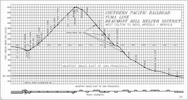
THE HELPER DISTRICT
SP is very fond of helper units on Beaumont Hill, between
Loma Linda Crossovers (MP541.3) and Indio (MP610.9). There are often many, many millions of
dollars of locomotives sitting at the PMT and Engine Spurs at Loma Linda,
waiting for the next eastbound to help push over the Hill.
Depending on the shortage of power for the District,
helpers can be switched in and out most everywhere along the Hill. Trains have been ordered to leave West
Colton and run as far east as they can before they stall; helpers rush
from Indio and other points to
eventually couple to such trains.
When a helper engineer gets the order from the dispatcher
to "run light", that means to finish whatever he's doing and
get his engine set going as soon as allowable to assist somewhere else
on the Hill.
Hanging out at most any siding on either end of the
Beaumont Hill will usually net some helper action during the course
of an active day; the best places to watch are Loma Linda, Thousand
Palms Crossover and Indio. But as I have said previously, units can
be found switching in and out at almost any other place in-between.
RAILROAD JARGON
I've considered trying to write a primer on the language
of railroading; this hasn't been simple since railroaders are humans,
just like you and I, and they tend to use different words occasionally
to describe the same thing or even make up new words and slang, conveying
the intended meaning through innuendo or familiarity. But here is a "minimal" listing
for those of you who don't listen to the scanner twenty-four hours a
day, or at least work for the railroad.
A few of the more interesting phrases sometimes heard are:
Stretch 'em out - Take out the slack in a train usually
by moving the locomotive forward a bit.
Bunch 'em up - Exactly the opposite. Remember that a 100-car train may have
a foot or two a slack between each car due to coupler and draft box
play; when the engineer applies the brakes the rear end of the train
doesn't get the message in a hurry due to all this slack.
When there were cabooses there was sometimes a cracked head or
two in the caboose when the slack caught up with the end of the train.
Bring it to a hook - Couple cars together.
Highball - OK to go. Throttle up. Pedal to the metal...
Come up against - 1) Tells the helper engineer in a
consist to push against the portion of the train between him and the
road engines at the front. 2)
Part of an order given by a dispatcher allowing a engineer to make a
movement against a stop signal and couple to a standing train, either
to lend helper service or to serve as road power.
That'll do - OK.
That's enough. Whoa,
horsey.
Scanner - Any one of the various equipment malfunction
detectors emplaced along the railroad.
There are so many esoteric and mysterious phrases used
by train crews that to attempt to list them all here would consume most
of the room reserved for real information.
The best way to learn the jargon is to tune in the radio for
many hours at a time and pay attention to the flow of traffic; then
when these mysterious phrases are voiced you might be able to piece
together the meaning. Or, you could ask someone who works for
the railroad... and maybe
get a completely different answer.
SECTION IV
RELATED SUBJECTS:
PRIVATE PROPERTY, RAILFANS AND TRESPASSING
The Southern Pacific Railroad is in the business of
providing a transportation service in order to make money; never forget
this. It does that by moving
material from Point A to Point C or perhaps Point Z. The railroad doesn't need you at Point
B or Point N fooling with the switchpoints or hanging off the signal
bridge, trying to get that one great picture of those eastbounds powering
up the grade (although it might be a tremendous picture; but I didn't
recommend it...).
Think of the railroad as a factory, a factory spanning
half the country. It has
a receiving dock that accepts the raw material and production lines
that process this material by moving it along great steel conveyor belts. The finished goods appear finally at the
shipping dock.
Now imagine you at your place of work having unauthorized
visitors sticking their hands and heads into your bending brake or file
cabinet or typing a few words on your computer. Although to you the railroad may present
unlimited photo opportunities or be the prototype for your model layout,
it is their company and their living.
Trespassing
I cannot condone trespassing; the legal difficulties
that could ensue would make me very unhappy. But as most everyone realizes, the railroads
are not generally fenced and there are few vicious guard dogs to protect
the rails from the curious. The
railroad employees (other than RR police) that I have met while poking
around have never yet asked me to leave the property; in fact, they
seem genuinely interested or at least amused that I as a railfan exist. After all, it's just a job to a lot of
them. They'd often rather
be somewhere else.
Railroad yards like West Colton
are another thing: I generally stay away from these places. The SP police are paid to look down on
folks climbing in-between classification tracks, poking their noses
into locomotives idling along the station or maintenance tracks, etc. And they are empowered by the State to
be real live Peace Officers, complete with the ability to arrest you
and carry a gun. If you
are intent on seeing facilities like this, ask permission first and
maybe they'll surprise you and say yes.
You have to realize, though, that they are liable for any injury
to you caused by your foolishness or carelessness and so they'd probably
rather not have you around.
A Few Trespassing Anecdotes
In one weekend while researching this Guide, I had two
incidents befall me regarding trespass.
(I can now look back upon them with some dark humor). The first was while driving along the paved
county road at MP579.4, stopping there a few minutes to jot some notes,
then turning off the pavement to follow the dirt path that parallels
the tracks to the east. Within
two hundred yards a CHP Mustang from out of nowhere had pulled me over
and, with hand resting on the butt of his pistol, the officer wanted
to know why I was out there and if I knew that I was trespassing on
Railroad Property. Of course, I was probably also trespassing
on Morongo Indian land, State and Federal land, etc., but I explained
that I was a railfan. Soon
he had my name and address and warned me that if he heard about any
trouble along the tracks I'd be the first suspect. And that was that. I sure hoped that there wasn't gonna be
any trouble around there for a day or two or three.
The second was the next day, under the Auto Center Drive
Overpass (MP611.4) at the Indio Yard. It was a hot (105 degree) day, twelve o'clock
high, and I parked under the bridge to stay cool, drink some water and
make some notes. This time
an Indio PD cruiser pulled up behind and I spent several tense minutes
explaining that I had nothing to do with the alleged in-progress vandalism
taking place on the train in front of me.
Finally the officer relaxed his grip on the holstered .357 when
he decided that I was too crazy to be lying.
He also discovered that he had grown up only three blocks from
where I live, so I suppose there was a certain kinship there.
Then he apologized and left me; his parting words were "Enjoy
the rest of your stay in Indio".
Railroad Property
You do not need souvenirs from Glamis siding. You don't need a Cabazon tieplate paperweight
or that bucket of spikes from Frink that weighs three hundred pounds
and makes your Ford Escort drag its rear bumper along the pavement. There is real scrap along the right-of-way,
but most of this you wouldn't want anyway: examples are the millions
(well, it seems like millions) of shoes on and in the ground at Garnet
Station or the Easter Baskets at Salt
Creek Bridge. The railroad probably wouldn't care too
much if you waltzed off with the shoes or the baskets. But then again, maybe they would.
Be wise. I
have listened on the radio to the railroad police arresting folks for
stealing piles of tieplates and spikes.
These items are worth good money, and the railroad can recycle
most all of the materials.
Federal, State and Local Government Property
There's a lot of this out there. Most of the desert still belongs to you
and me, with the Federal Government as caretaker (more or less; mainly
less). Some people look
on this as a bad thing; but for the most part, it's better than running
into barbed-wire fences every few miles and dealing with folks carrying
shotguns.
The railroad, once out of the San Gorgonio Pass, leaves
the confines of suburbia and sails through mainly uninhabited terrain.
Here the land surrounding the tracks is owned by a variety of
governmental agencies; for the most part, no one will bother you and
no one particularly cares. But so long as you are next to or near
the tracks, you are most likely on railroad land and that is private
property.
Indian Reservation
Land
Indian Reservations are private property; these folks
own that land and are free to make their own rules regarding trespass. They generally have their own police force,
and sometimes even their own jail.
But generally, as long as you aren't tearing up their land, or
stray too far from the beaten path, it's unlikely that you'll ever see
them. But again, it is private property, and
you are trespassing.
Trespassing On Anything Else
Although a great deal of the land along the right-of-way
belongs to the Federal, State or local Government, there is also a lot
of private land. The first
rule is: If you are on the wrong side of a "NO TRESPASSING"
sign you can get into trouble.
The second rule is: Even if there aren't any "NO TRESPASSING"
signs visible, if someone comes along and tells you that you're trespassing,
you might do well to pay heed.
They might be wrong, but unless you're in a position to prove
that to their satisfaction, you may want to move on.
Fruit orchards and farms line the tracks in places.
Farmers can get very upset if they find you filching their oranges
or whatever. Section 484 of the California Penal Code
makes it a FELONY to swipe fruit...
and there are signs all over that repeat that! When I stop at a store and buy fruit,
I even carry the receipts around with me until the fruit is gone and
I've buried the refuse. But
I'm paranoid. Being thrown
in jail for six months for having an illicit, 20-cent orange in the
back seat isn't worth it. (It's
a silly law, I agree; in fact, I'd say that it was cruel and unusual
punishment.)
Hanging out under that bridge or on that hill you may
be RAILFANNING, but other folks (the residents of wherever) might call
it LOITERING. The police
can then bring you TROUBLE.
Support Your Local Railroad
An important thing to remember is that you, as a rail
watcher, can provide an extra set of eyes and ears to the railroad. If you're out along SR111 by Ferrum Siding,
along the east shore of the Salton Sea,
and see some nasty-looking types vandalizing railroad property, report
it. Find a phone at your earliest convenience
and call the SP Police, the county Sheriff
or the Highway Patrol. They'll
appreciate it and maybe, just maybe, you'll engender a little respect.
In Parting
The Southern Pacific Transportation Company would like
railroading to remain a paying, profit-making business, with as few
liabilities as possible. If
you abide by the rules, you help out the SP, they can go about their
business of running more trains and in return you can enjoy the hobby
that much more.
Once again: Don't take railroad property, don't fool
with railroad equipment, don't get in the railroad's way, but always
have FUN. It's a hobby,
after all.
|